How to view Prayer Coverage as an organization

Using the map, you can view the cumulative nationwide Pray-Care-Share progress of all of the Lights in America.
To enable these overlays, click the 'Prayer Coverage' heading in the 'Layers' section of the control panel. Doing so will expand the section revealing the 5 different layers that you can view.

Click one of the layers to activate it on the map.
Below are the definitions for each of the 5 types of overlays in the 'Prayer Coverage' Layer that can be viewed with a Bless Partner subscription.
- Adopted: Homes that appear on at least one prayer list of a Light who is using Blesseveryhome.com.
- Prayed: Homes that have at least one Light who has recorded one or more prayer for the occupants of that home.
- Cared: Homes that have at least one Light who has recorded a care action such as an act of service for the occupants of that home.
- Shared: Homes that have at least one Light who has recorded that they have shared the gospel with someone living in that home.
- Discipled: Homes that have at least one Light that has identified the occupants of that home as being a follower of Christ.
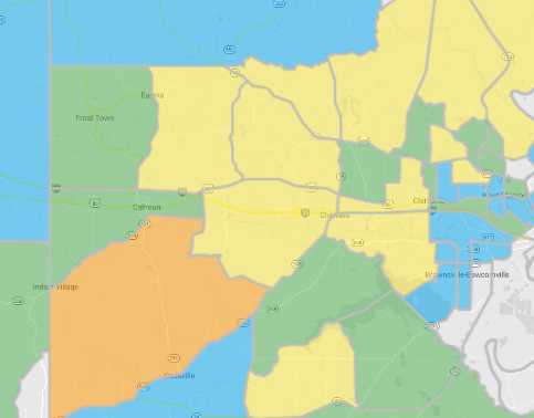
Activating any of the 'Prayer Coverage' layers will cause your map to be divided into sections. These sections will change depending on the current scale of your map. The current map scale can be found in the bottom-right corner of the map. At 1 mile/2 kilometers or less, the map will be divided into Census Block Groups. These are geographic divisions used in the census that typically contains between 600 and 3000 residents. At 2 miles/5 kilometers or more, the map will be divided into counties, parishes, and boroughs.
The sections of the map will be shaded a different color depending on the percentage of homes in that section that meet the criteria. View the legend in the control panel to decipher the information.

Related Articles
Partner Church Coverage Page Overview Video
Note: some of the functionality may have changed since these videos were made.Signing up your church or networked ministry
Creating your church, association, or ministry within Blesseveryhome.com will give your organization access to our powerful ministry services. The signup process only takes a few minutes to complete. We recommend that only organization staff or ...LIGHT Coverage Page Overview Video
Note: some of the functionality may have changed since these videos were made. View the next video in this series: LIGHT Profile Page Overview VideoHow to create a prayer list for a church member that doesn't use the Internet.
In the event that one of your church members does not use the Internet but still wants to pray for their neighbors, you can create a prayer list for this person. To do so, use the following steps: Navigate to our 'Account' page. If your account only ...How to view individual Lights associated with your church
As a Partner Church, you have the ability to view a list of the Lights currently connected to your church and log in to their account to view their spiritual journey. From the dashboard, you can view how many Lights are in your church. Click on the ...