How to Create a Project
Creating a Project
Begin by clicking the 'Map' tab on the left-hand side of your account dashboard.
Once you are there, click the 'new' icon in the 'Projects' section of the control panel.

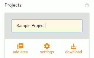
When you first click the 'new' icon, your cursor will default to the project name field. Give the new project a name by typing in the box.
Adding and adjusting areas
The next step is to add areas that you would like your project to encompass. When first creating the project, the 'add area' section of the 'Projects' section will be open. You should see '+circle', '+rectangle', and '+polygon' buttons in the control panel. If you do not see these buttons, click the 'add area' icon. Click any of the shape buttons to add one of those shapes to your map. Below are descriptions of each of the areas you can add.
+circle
Click '+circle' to add a round area to your map.

Drag the white dots on the edge of the circle to adjust the size of the circle.
After making an adjustment to the size of the circle, you can click the back arrow that appears next to the part you moved to quickly undo the last move.

At the center of the circle, you will find a measurement label that shows the distance in miles from the center point of the circle to the outer edge of the circle (the radius).

Tip: To find the diameter of the circle, simply double the value of the radius. To find the total area of the circle, use the following formula: Area = π (radius²)
+rectangle
Click the '+rectangle' button to add a four-sided shape to your map.

Drag the white dots in the corners of the rectangle to adjust the size of the shape while preserving its aspect ratio.
Drag one of the grey dots found at the mid-point of each side of the rectangle to adjust only that side. This allows you to make the shape taller or wider.
After making an adjustment to the size of the rectangle, you can click the back arrow that appears next to the part you moved to quickly undo the last move.

+polygon
The polygon tool allows you to create a completely customized shape on the map. When you click the '+polygon' button, your cursor will turn into a cross shape when hovering over the map.

Begin creating the shape by clicking on multiple locations on the map. You will see lines connect each of the places that you click. When you have surrounded the area you want included in your project, double-click when placing the last point to close the shape. Alternatively, you can click on the first point you placed again to close the shape.
Once the polygon has been created, you can adjust the shape by dragging any of the white dots found at the corners of the shape.
Clicking and dragging any of the grey dots found in the middle of the straight lines between the corners will create a new corner. Use this method to make your shape even more complex and specific.
After making an adjustment to the shape of the polygon, you can click the back arrow that appears next to the part you moved to quickly undo the last move.

TIP: You can also add predetermined boundaries such as zip codes and counties to your project. Please CLICK HERE to learn more about boundaries.
Any shape created with the '+circle', '+rectangle', or '+polygon' buttons can be easily moved by clicking and dragging anywhere inside of the grey shaded area of the shape. A predetermined boundary such as a zip code cannot be moved.
Deleting shapes
To delete a shape from the map, click once anywhere in the grey shaded area of the shape. This will cause a trash can icon to appear. Clicking the trash can will cause the shape to be permanently deleted from the map.
.
TIP: If you are deleting a shape that overlaps with another shape on the map, be sure to click in an area that doesn't overlap. This will prevent you from accidentally deleting the wrong shape. Overlapped areas appear darker.Project settings
To access the settings for a project, click the 'settings' icon in the 'Projects' section of the control panel.

Use the toggles on the following settings to apply them to your current project.

- 'Show inside project only': Apply this setting to only have households appear on the map within the areas of the project's current shapes.
- 'Consolidate mailing addresses': Apply this setting to have only one entry per mailing address be included in downloads of projects. This can be useful when using a project download to create a mailing campaign where duplicate addresses would be undesirable.
Below the toggles, you will find a place to add an optional description for the project. Click the placeholder text, 'Description of project', and type a description.

Saving the project
When you are done creating and customizing your project you will need to save the project if you would like to access it again in the future.
Give the project a name if you did not do so already. Simply click area at the top of the 'Projects' box to give the project a name, or change the current name. You will know that the project has not yet been named if the grey box at the top of the 'Projects' box reads 'Project Name'.
Once the project has a name, click the 'save' icon in the bottom left corner of the 'Projects' box to save the project.

Warning: Leaving the map or refreshing the page without saving the project will cause any unsaved changes to be lost.

Note: Saved projects can be viewed and edited by all current administrators of your organization in your church's account.
Updating a project
If you have made any changes to an open project, you will need to save the project again for those changes to be present the next time you open the project. If the 'save' icon is orange, there are unsaved changes in the current project. Click the 'save' icon to save these changes
If the 'save' icon is greyed out, that means that there are no changes to save.

Related Articles
How to create a mailing list for a specific neighborhood
Go to the Map tab on your church's account. Then select "Households" Click on the filter you would like to apply. For this example we are using "Children present." Deselect "Children not present" Scroll down to "Projects" and select "New" You can ...How to Sign up for The BLESS App
You can sign up for the BLESS App one of two ways: 1) By signing up on our mobile app 2) By signing up on our website Both processes will be listed below, so find the one that works best for you and follow along! Signing up on our mobile app 1) Go to ...How to edit your contact information as a Light connected to a Church
Note: This is only applicable on the mobile app. 1) Sign up to be a light Begin by creating an account. To do this, click THIS LINK or check out this help desk article: Signing up to be a light Once you signup, it will ask if you would like to 'Make ...What each subscription includes
Once you create an organization or church account with The BLESS App, you have the option to subscribe to one of three subscriptions. These include: BLESS Partner, New Movers, and Community Connector. If you are a church, you have the option to ...Can I see other people in my neighborhood that are using the service?
To see other Lights in your neighborhood, click the 'Map' tab on the left-hand panel. Click the waving hand in the bottom right corner titled 'Lights in my neighborhood'. You will be able to see all of the other Lights in your neighborhood that have ...